Walking in the UK | The 8 best hiking routes in Scotland
- Overview
What’s special about hiking in Scotland?
Scotland is home to some of the most beautiful mountain ranges in the world. In fact, millions of years ago, the Scottish Highlands were part of the same rock formation as the Appalachian Mountains in modern day America. Famous for its unpredictable and gloomy weather, Scotland is perfect for you if you like a challenge.
Every step across this diverse landscape gives a fresh insight into the past. From the towering mound that is Arthur’s Seat in Edinburgh and the jagged formations on the Isle of Skye, the otherworldly quality that is rural Scotland gives us a glimpse of what the earth looked like millions of years ago.
Mysterious lochs, ancient forests, and historic castles mean there really is something for everyone. Trails like the West Highland Way showcase stunning views for those after a photo opportunity, and the tourism that’s built up around areas like Glencoe and the Aberdeenshire countryside mean squeezing a weekend away in to explore what’s on offer has never been easier.
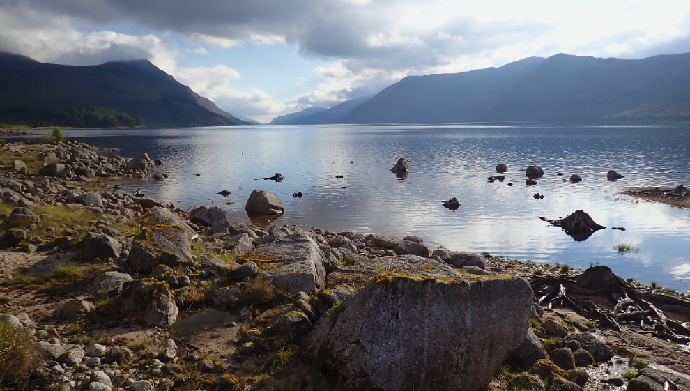
World famous lochs
World renowned for its lochs, Scotland has some of the most stunning expanses of open water on offer in the UK. Many of these are popular tourist attractions that attract hundreds of thousands of people looking to experience the beauty, mystery, and intrigue that these picturesque spots offer every year.
Whether you’re looking to lose yourself in the folklore of these ancient bodies of water, or you’re just after a stunning photo op, look no further. Some of the best lochs to visit include Loch Lomond, Loch Ness, Loch Awe, Loch Fyne, Loch Tay, Loch Katrine, and Loch Earn.
1. Dunnottar Woods circular
- Distance: 2 miles
- Difficulty: easy
- Location: Stonehaven, Aberdeenshire
Dunnottar Woods loop GPS route
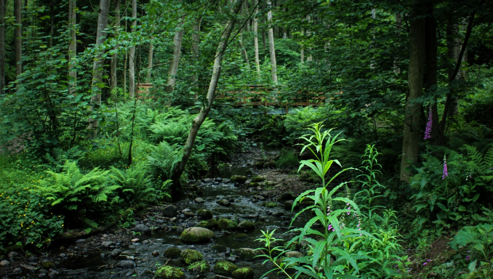
Few woods in the northeast of Scotland are as naturally diverse as Dunnottar. A captivating natural area located near Stonehaven in Aberdeenshire, Dunnottar Woods are nestled off the A92, making them easily accessible if you’re visiting by car.
Dunnottar Woods are a serene escape into a lush, green woodland that can look drastically different depending on when you visit. Steeped in history and stories about the Kennedy family who used to live in Dunnottar House in the forest, Dunnottar is a great walk for young children. Much of the walk follows a marked trail, making it easy to follow and navigate.
2. The Lost Valley waterfall walk
- Distance: 2 miles
- Difficulty: easy
- Location: Glen Coe Nature Reserve
Lost Valley waterfall walk GPS route
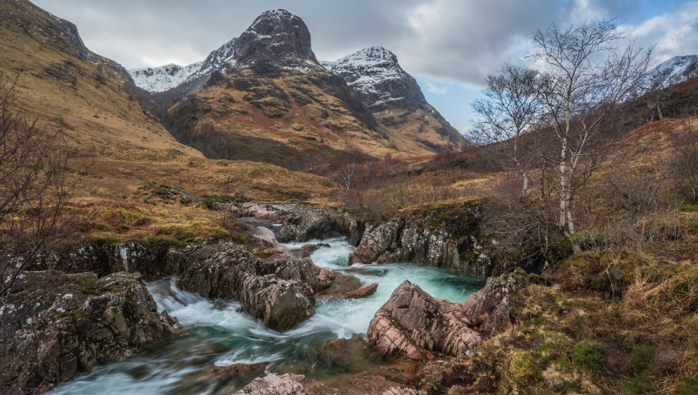
Despite the natural beauty of the country, you’d be hard pressed to find a better view than that of the meandering brook and distant ice capped mountain tops from the Lost Valley at Glencoe.
On this unique trail you're treated to stunning views of the River Coe and the delightful sight of cascading waterfalls.
Start your journey at the complimentary Three Sisters Car Park located on the A82, which serves as an excellent vantage point for the imposing trio of mountains above.
As you set off, you'll find well-defined footpaths that lead south-eastward toward the Meeting of Three Waters. Here, we recommend taking a minute to take in the enchanting waterfall that awaits.Continuing on, your path stretches southward, allowing you to drift off from the trail (if you want to) in order to explore the mountains and waterway offshoots on offer inside this picturesque hidden valley.
3. Beinn Eighe
- Distance: 3 mile
- Difficulty: medium
- Location: Beinn Eighe National Nature Reserve, Scottish Highlands
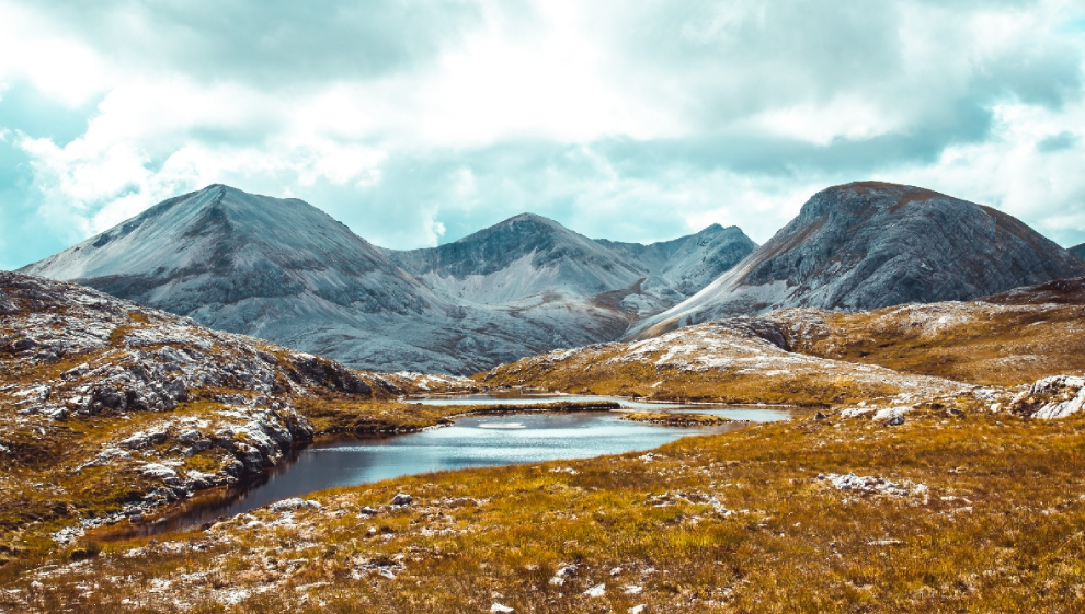
This picturesque trail takes you on a rugged circular path on and around the Beinn Eighe Mountain, giving you inspiring views of the nature reserve below.
On your hike you’ll pass through pinewood forests that sit beside majestic mountain lakes and pristine white quartzite crags that are unique to the area. The breath-taking views that unfold showcase the full beauty of Loch Maree and the Torridon Mountains.
To start, meet at the car park situated at the southern tip of Loch Maree. This is the gateway to the well-marked mountain trail you’ll be sticking to. Prepare yourself for a challenging walk with steep incline sections and rocky terrain.The path quickly moves upward, so be sure to wear suitable warm clothing. You’ll traverse woodlands and trace the babbling burns cascades, ultimately reaching the summit of Beinn Eighe where views of the tranquil loch and cairn below make your hard work worth it.
4. Arthur’s Seat and Holyrood Park
- Distance: 3 miles
- Difficulty: medium
- Location: Edinburgh
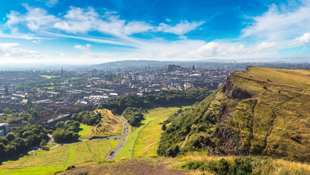
Few walks in the UK are as instantly recognisable as Arthur’s Seat. Towering over the Edinburgh skyline, this iconic mound is a challenging ascent that offers an unrivalled view of the city below. You can finish the hike in an afternoon, making it a must for outdoor enthusiasts on a weekend away in Edinburgh.
Geologically, Arthur’s Seat is actually part of the Arthur's Seat Volcano, which is a designated a site of special scientific interest. Shaped by an extinct volcano system from the Carboniferous era and similar to the rock foundation used in the construction of Edinburgh Castle, this hill was sculpted by glacial activity approximately 350 million years ago.
The quickest path to the summit starts at Dunsapie Loch, just east of the hill. An adjacent car park facilitates easy access, and trails ascend from the loch toward the summit, a brief distance away. Starting at the palace's nearby car park, your journey begins by heading east as you scale the heights of Salisbury Crags. This vantage point grants stunning views back to the palace, with the Scottish Parliament and the Firth of Forth visible on clear days.You’ll pass the site of Gutted Haddie en route to the summit which is the site of an ancient hill fort. After absorbing the panoramic views, the descent leads to the remains of St Anthony's Chapel. These evocative ruins perch atop a rocky outcrop, overlooking North Edinburgh, Leith, and the River Forth. Continuing the descent brings you to St Margaret's Loch, where waterfowl grace the serene waters.
Proceed past the natural spring at St Margaret's Well before concluding your journey at the car park. Nearby, the captivating Dynamic Earth visitor attraction beckons exploration. With a primary focus on enhancing public comprehension of Earth's shaping processes—ranging from the Big Bang to plate tectonics and glaciation—Dynamic Earth offers an engaging experience.
5. The Quiraing climb loop
- Distance: 4 miles
- Difficulty: medium
- Location: The Isle of Skye
The Quiraing climb loop GPS route
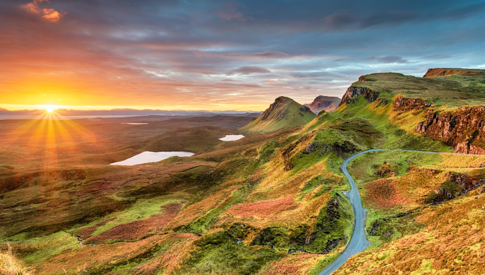
Hiking the Quiraing on the Isle of Skye is one the most popular routes in Scotland. This iconic and distinctive landscape has an otherworldly feel to it that provides stunning views and photo opportunities for hikers, walkers, and trekkers alike.
This iconic circular trek leads you to the world famous Quiraing, situated in the northern expanse of the island. Noteworthy as the northernmost peak of the Trotternish peninsula, the Quiraing has a reputation as one of the most stunning and picturesque sights to see on the island.
Its unique terrain provides unparalleled views that are straight out of a fairy-tale, rendering this route as one of the premier walking attractions in the region.The trail spans runs for around 4 miles and takes roughly 2 to 4 hours to complete depending on how long you spend taking in the stunning surroundings. Starting at the Quiraing Car Park, chart a course north-eastward, past the iconic Prison and the jagged Needle before looping back to complete the circuit. As you walk you’ll pass stunning valleys, cliff edges, pinnacles, and rocky peaks that encapsulate the rough historical landscape of Scotland.
6. Tay Forest Park loop
- Distance: 8 miles
- Difficulty: medium
- Location: Perthshire
Tay Forest Park loop GPS route
Tay Forest is home to the picturesque Black Linn Falls, the jagged skirt track of Creag an Uamhaidh, the unique Pine Cone Point and a viewpoint that gives an unrivalled aerial view of Craigvinean forest (home to the Mighty Douglas Fir which is apparently Britains tallest tree at 64.6m).
This diverse hike covers different terrains and altitudes in a short space of time. You’ll want hiking boots and a warm jacket for this one. Starting at the Hermitage Woodland car park, you can familiarise yourself with the Douglas fir trees which litter the woodland trail.
As you make your way northward, you’ll discover a network of woodland trails within the expansive Craigvinean Forest. Feel free to leave our trail if you’re in the mood for some off-piste exploration. Inside this natural forest haven, you'll encounter charming streams and magnificent viewpoints that offer glimpses of the neighbouring Ben Vrackie. It's worth noting that a significant portion of this route is well-suited for cyclists to enjoy as well.
7. Loch Ericht
- Distance: 11 miles
- Difficulty: medium
- Location: Dalwhinnie, Scottish Highlands
Walking and hiking around Loch Ericht is a real adventure. Loch Ericht is an expansive lake situated between Perth, Kinross, and the Highlands. Around the loch are numerous paths where you can walk or ride a bike. These paths vary in altitude, providing you with great views of the lake. Some are more challenging than others, including the mountain summit at Ben Alder.
This particular route guides you along the loch's western edge, passing through the serene Ericht Forest. Your journey starts at Dalwhinnie train station which is a quant little station nestled at the northern tip of the loch.
Here, you can access footpaths that guide you southward through the Ben Alder estate, tracing the tranquil Lochside path all the way to the water. Culminating at the Ben Alder Lodge, you have the option to extend your adventure further if you want to.Alternatively, you can choose to venture westward to the nearby Loch Pattack where you can ascend the remarkable Ben Alder. Ben Alder gives an unrivalled view of the loch below and makes a great challenge for experienced hikers.
Arriving at the loch's southern terminus, you’ll see a seamless connection path that links up with the River Ericht. The imposing dam you’ll see here makes for an impressive sight. Following the course of the river southward, you'll arrive at the shores of the neighbouring Loch Rannoch, which completes your journey.
8. Ben Nevis mountain climb
- Distance: 11 miles
- Difficulty: hard
- Location: Fort William, Scottish Highlands
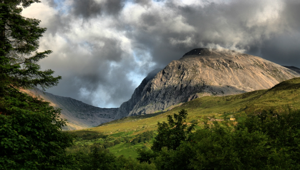
Ben Nevis is the UK's tallest mountain. Situated in the Scottish Highlands near Fort William, its iconic peak reaches 1,345 meters (4,413 feet) above sea level. Climbers and outdoor enthusiasts alike tackle the Ben Nevis Mountain Track in search of stunning views, where you’ll pass through diverse landscapes, including rugged terrain and the serene Loch Meall.
Begin by making your way to the Glen Nevis visitor centre car park, located in the charming town of Fort William the Scottish Highlands. The visitor centre is a valuable resource with lots of helpful advice and information, especially if you're not used to climbing hills.
Even though this path is the most direct way up the mountain, it's still quite challenging. Pay particular care when climbing the upper part which is rocky and rough. Make sure you have sturdy hiking boots, extra clothes, and enough food and water to last you a number of hours.The hike can take anywhere between 7 and 10 hours, so it's best to save an attempt for the longer days during summer. As you leave the visitor centre, you'll cross the River Nevis before you begin your ascent. While you're climbing, you'll be treated to breathtaking views of Glen Nevis, the Mamores, and Stob Ban. Along the way, you'll pass by charming streams and the peaceful Loch Meall.
When you reach the summit, you'll find various memorials, a trig point, and many piles of stones called cairns. The vistas of the Scottish Highlands from up there are truly spectacular and make the effort you put into your ascent well worth it. For the return journey, you'll follow the same path back to where you started.
Honourable mentions
We couldn’t include everything Scotland has to offer in our list. If you’re looking for something different, take a look at some of the walks, hikes, and paths listed below:
- West Highland Way
- Cairngorms National Park
- The Fife Coastal Path
- Fairy Pools (Isle of Skye)
- Tay Forest Park
- Glenfinnan Viaduct
- Hellvellyn
- Glen Affric and Loch Beinn a’Mheadhoin
Last updated Wednesday 13 September 2023
First published on Wednesday 13 September 2023