Walking in the UK | 8 great paths and routes in the Midlands, Yorkshire and Humberside area
- Overview
What’s so special about these areas?
The unique topography of this part of the country means rolling hills and undulating valleys are plentiful. With such a large degree of overlap in geographical definitions here, you can fairly easily drive a few hours north or northwest and visit the North Pennines and the Lake District for some more incredible hikes.
If you’re looking for length when it comes to hiking, the Yorkshire Dales and Peak District National Park are must-visit areas. Farmland is everywhere here, and trails are no different. Streams, valleys, and waterways litter the countryside, guiding you along some of the most trodden pathways the country has to offer.
Must see outdoor areas
If you’re after some more inspiration, pay a visit to any of the stunning locations listed below:
- Lincolnshire Wolds Area of Natural Beauty
- Yorkshire Dales National Park
- Peak District National Park
- Nidderdale Area of Natural Beauty
- Cannock Chase Area of Natural Beauty
- Laughton Forest
- Queen Elizabeth Diamond Jubilee Wood
- Clumber Park
- Hatfield and Thorne Moors
- Wyre Forest
1. Humber Bridge Walk
- Distance: 4 miles
- Difficulty: easy
- Location: Hull, East Riding of Yorkshire
- Humber Bridge crossing walk GPS route
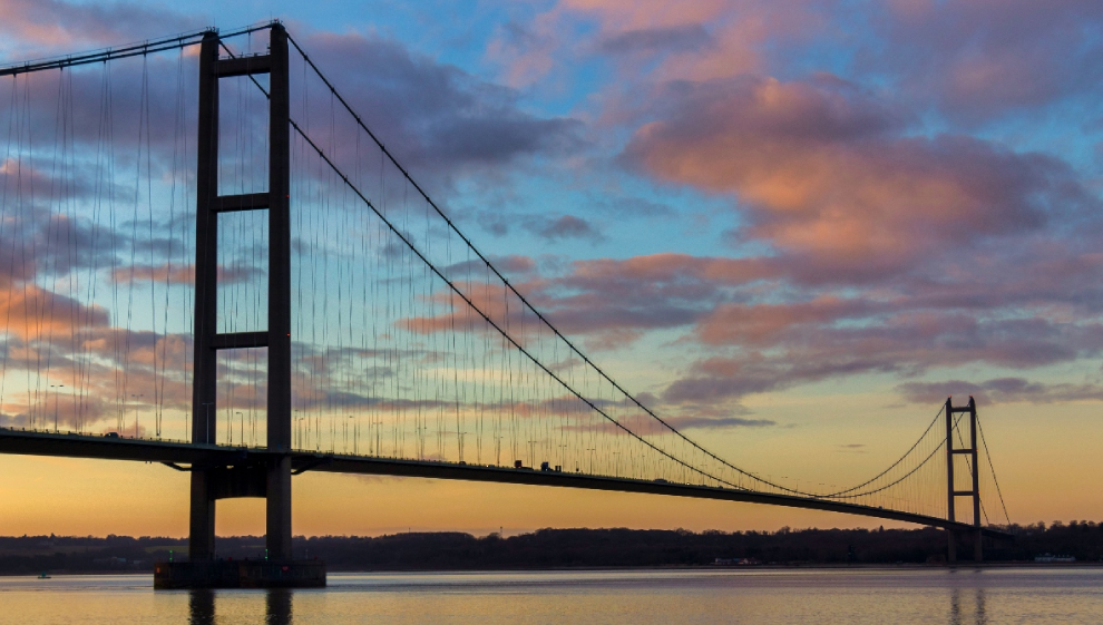
Opened in 1981 as one of the longest suspension bridges in the world (2,220-metre or 7,280 ft long), the Humber Bridge bridges the Humber Estuary to link the county of East Riding and Yorkshire with the city of Hull.
On top of being an engineering marvel, the estuary surrounding the bridge is a haven for marine and wildlife. The area is home to a wide array of bird species and if you’re lucky, you might even catch a glimpse of some seals basking on the mudflats at either end of the bridge.
If you’re interested in marine life, Hull is home to the “The Deep” and is well worth a visit if you’re holidaying with young children. This world-famous aquarium is home to over 300 species and around 5,000 animals overall and is roughly 15 minutes by car from the Hull side of the crossing.
If you’re looking for something a bit more rural to top off your walk, the adjacent Humber Bridge Country Park is full of woodland and meadows and is situated immediately right of the Hull side crossing entrance
2. Cannock Chase Country Park
- Distance: 6 miles
- Difficulty: easy
- Location: Cannock Chase Area of Natural Beauty, Midlands
- Cannock Chase loop GPS route
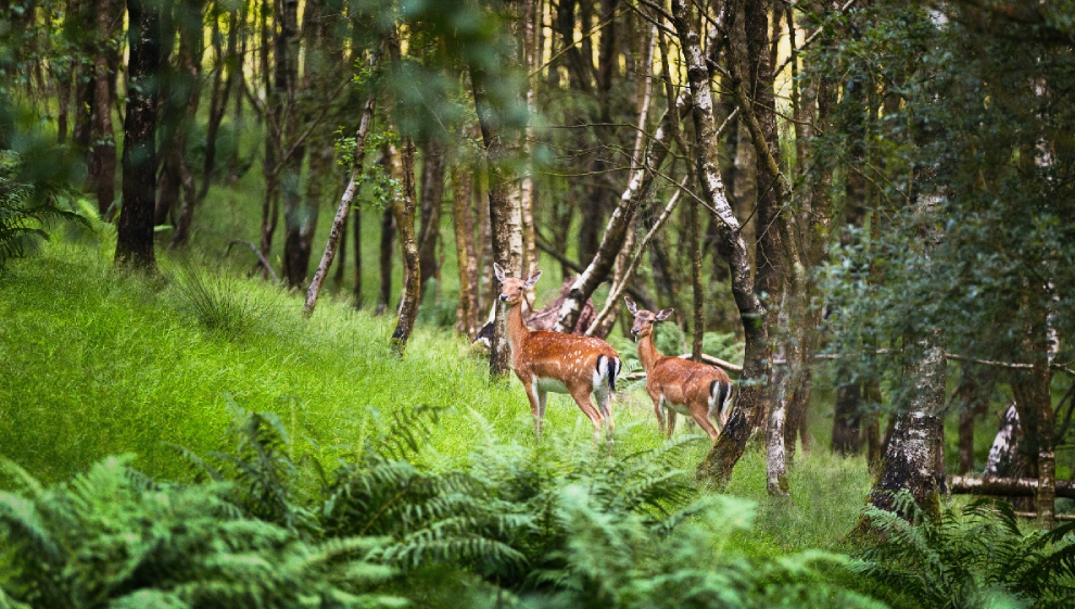
Cannock Chase is a designated area of outstanding natural beauty (AONB). Categorised for preservation because of its significant natural value and wildlife status, the area is so much more than just a forest.
Cannock Chase is situated just north of Birmingham. With an abundance of activities to keep you and your family entertained, it’s well worth a visit for nature and hiking enthusiasts and families alike. With a dedicated children's play area, Go Ape adventures, orienteering trails and a dog activity trail, there's something for everyone..
The woodlands cover approximately 26 square miles and are made up of a mix of woodlands, heathlands, and wetlands. The sire is also a Site of Special Scientific Interest (SSSI) due to its unique ecology and geology. The forest has a rich history, with archaeological sites including the remnants of a prehistoric settlement and ancient burial mounds. It also played a role in World War II as a training ground for British and American troops.
A number of long-distance, well-marked trails crisscross Cannock Chase, including the Two Saints Way, Heart of England Way, and the Sabrina Way. If you venture a short distance east from the park, you'll discover Milford Common, where charming trails wind through grassland and woodland, providing a delightful hiking experience.
3. Viking Way circular walk
- Distance: 11 miles
- Difficulty: easy
- Location: Lincolnshire Wolds
- Viking Way circular walk GPS route
The full Viking Way is a long-distance trail named after the routes Viking invaders took in the northeast over a thousand years ago. The full route is a 150-mile trail running from Oakham (a village east of Leicester) all the way up to Barton Waterside on the banks of the Humber in the northeast.
This circular is a shorter version that follows a stretch of the path from Woodhall Spa east of Lincoln. On the way you’ll pass St.Peter's church in Stixwould. This church was rebuilt in 1831 and is home to an incredible late 14th century font. The trail sees you walk the banks of the River Witham around a picturesque set of farmers fields before looping back to town.
4. Dovedale circular walk
- Distance: 10 miles
- Difficulty: medium
- Location: Dovedale Nature Reserve, North Ashbourne
- Dovedale loop GPS route
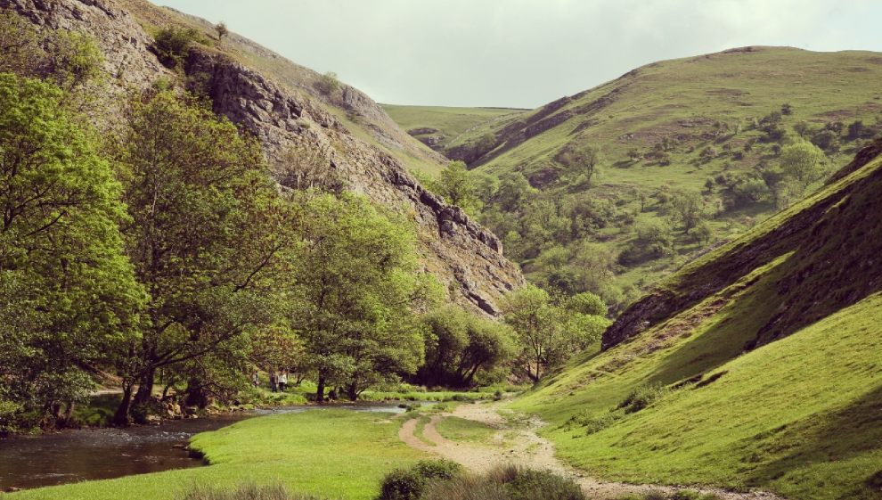
The Dovedale circular is one of the most popular routes in the Midlands. Hikers flock to the area for good reason, with eye-catching rock and cliff formations and scenic views of the meandering River Dove on offer.
Clocking in at 10 miles in length, this leisurely hike is accessible whilst still being challenging. Wander through picturesque rolling hills and up and down valleys as you walk beside the River Dove all the way south to the quaint village of Thorpe.
Along the way you’ll be treated to close up views of Ilam Rock, the famous Dove Dale stepping stones, Reynard’s Cave, the adjacent Tissington Trail and the rolling hills it plots through, and the mysterious Dove Hole cave etched into the Dove River’s cliffside.
5. Spurn Point
- Distance: 8 miles
- Difficulty: medium
- Location: Hull, Lincolnshire
- Spurn Point walk GPS route
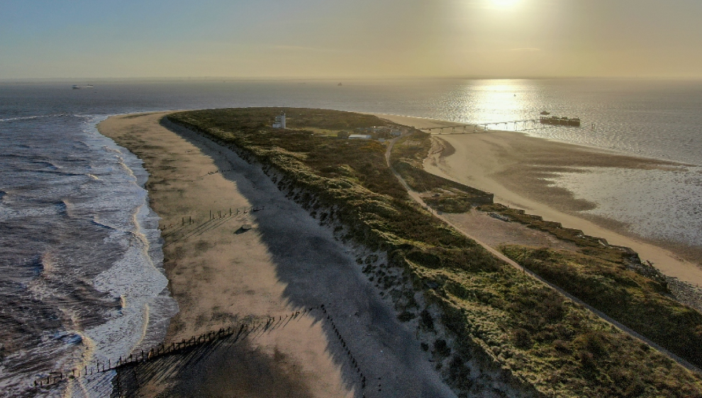
Spurn Point is a unique and fascinating natural sand and shingle spit that extends into the North Sea. It separates the estuary of the River Humber from the sea and makes for a fantastic hike, especially as the sun is rising and setting over the horizon.
Spurn Point is known for its exceptional beauty, diverse wildlife, and distinctive geography. It’s a popular destination and makes for an entirely unique 8-mile hike. The area is constantly changing due to erosion and deposition processes, making it an ever evolving and wholly unique ecosphere. The narrow strip of land extends for approximately 3.5 miles and is one of the best places in the UK to witness first-hand the interaction between land and sea.
To access Spurn Point, head to the Kilnsea car park. From here, head southward, passing by the Spurn Bird Observatory and Kilnsea Warren. Continue your journey down the peninsula until you arrive at Spurn Head. On a good day, several thousand birds can be observed in and around the nature reserve located here, making it a much visited hotspot for bird watchers in the area.
If you visit in September, you'll have the opportunity to spot some common and grey seals as they come in to feed on the shoreline.
Before visiting Spurn Head, make sure to take note of tide times. Walking to the end of the spit at high tide can be dangerous. It’s crucial you plan your visit with this in mind.
The route ascends further into the hills south of the river, with elevations exceeding 1300 feet around Whiteholm Bank. Along the ascent, you'll be treated to panoramic views of the surrounding area and woodland below. The trail finishes up by moving back down to the river and car park.
6. Malvern Hills
- Distance: 8 miles
- Difficulty: medium
- Location: Malvern Hills Area of Natural Beauty, Midlands
- Malvern Hills walk GPS route
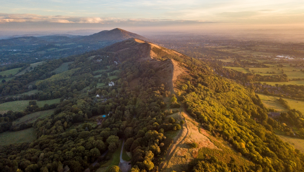
Sprawling across Herefordshire and Worcestershire, the Malvern Hills are a protected area of natural beauty for good reason.
These famous undulating hills offer unrivalled views of the surrounding area, including the Severn Valley, the Cotswolds, and the Welsh mountains.
The Malvern Hills are famous for their natural springs, which have been a local water source for centuries. Malvern water is famous for its purity and was even used by Queen Elizabeth I. Today, you can still find and enjoy the spring water in the hills.
This walk takes you the full length of the hills, from End Hill in North Malvern to Chase End Hill at the southern end.
To get started, head the car park at North Malvern. This scenic hike takes you through End Hill, Table Hill and Sugarloaf Hill on your way to the Worcestershire Beacon.
The route meanders through Jubilee Hill, Black Hill, and Herefordshire Beacon. Here you will find an Iron Age hill fort and reservoir. Next you come to Hangman's Hill, and Swinyard Hill before arriving at the interesting Midsummer Hill where you will find an Iron Age hill fort which spans Midsummer Hill and Hollybush Hill.
7. Beacon Hill Country Park and climb
- Distance: 2 miles
- Difficulty: medium
- Location: Beacon Hill, Loughborough
- Beacon Hill climb GPS route
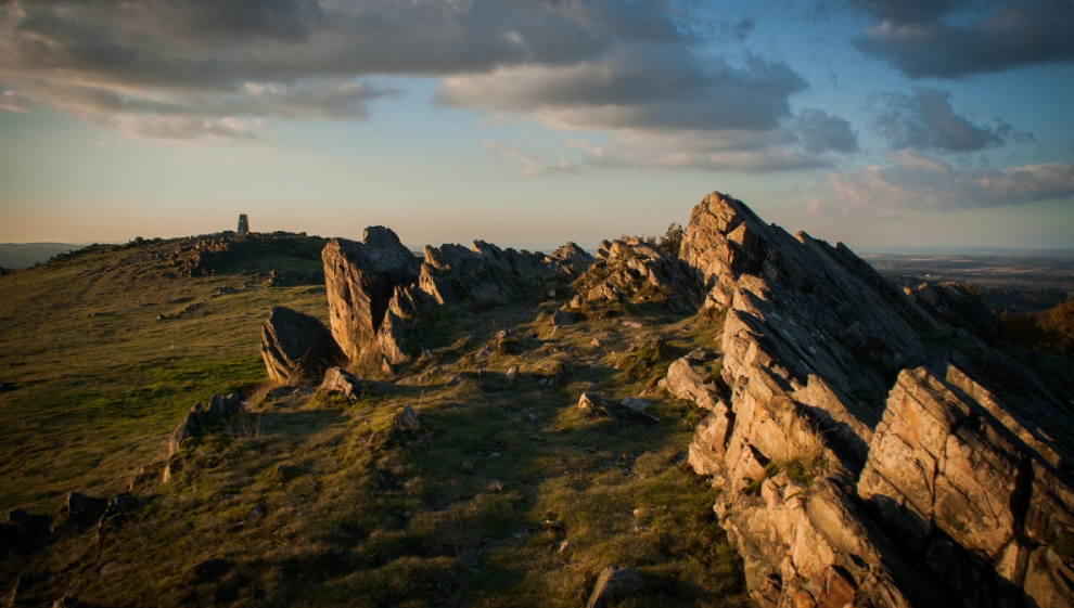
Beacon Hill lies inside the country park of the same name.
This short, sweet and challenging hike sees you ascend to the summit of the hill at the west end of the park, before circling back to the eastern carpark.
Home to a lush conservation area and a number of intersection trails, the park is worth a visit in its own right.
If you’re here to climb Beacon Hill and for the unrivalled view of the surrounding Leicestershire countryside, make your way west from the carpark. It’s worth taking a brief detour through the conservation area on your way to Beacon Hill.
The hill itself is 245m high, making it a challenging but largely accessible ascent suitable for hikers of varying ability and experience. At the top, you’ll find jagged rock formations and the ruins of an iron age fort. There is also a toposcope at the summit, giving you instant landmark reference points in all directions.
After you’ve taken in the views of the surrounding area, you can enjoy an additional conversation area to the north of the hill before heading back to the carpark.
8. The Yorkshire Three Peaks
- Distance: 25 miles
- Difficulty: hard
- Location: Yorkshire Dales National Park
- Yorkshire three peaks climb GPS route
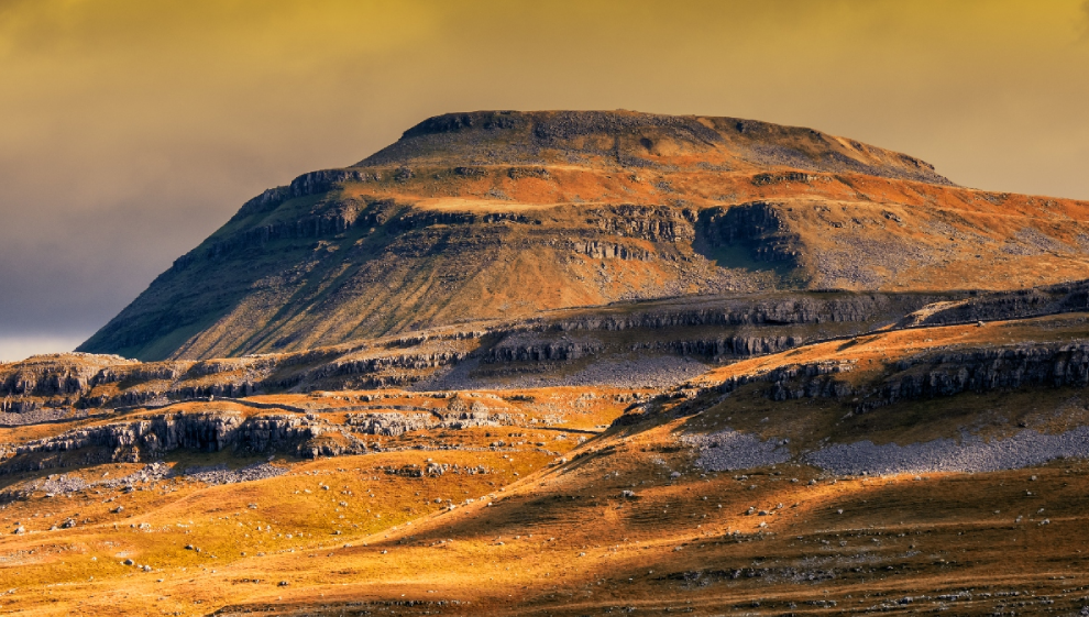
The Yorkshire Three Peaks is a challenging expedition that involves climbing the three highest peaks in the county as quickly as possible. These are Pen-y-Ghent (694m), Whernside (736m), and Ingleborough (723m). These three formidable hills are part of the Pennine range which encircles the head of the River Ribble valley within the picturesque expanse that is the Yorkshire Dales National Park.
Typically, these lofty peaks are tackled in this specified order within 12 hours. Attracting thrill seekers and outdoor enthusiasts, this challenge is the opposite of a relaxed hike. If you don’t like the sound of a time constrained challenge, you can enjoy these climbs in a more relaxed fashion over the course of a day or two.
This challenge can be undertaken as part of an organised and paid event, or as an independent group adventure.
Before starting, it's important that all participants understand the physical nature of the challenge they’re undertaking. To complete this hike, you need to be in excellent physical condition as the challenge involves hiking throughout an entire day with little room for stops or rest periods.
The primary objective of the classic challenge is straightforward: complete the circular hike in under 12 hours.
The journey starts in Horton in Ribblesdale before heading out towards Pen y Ghent. The footpath ascends to the summit by way of Brackenbottom Scar before descending along the Pennine Way, passing through Tarn Barn, Horton Scar, Jackdaw Hill, and Hull Point (the largest natural cavity in England)..
The expedition then moves out to Whernside past caves, streams, and cascading waterways as it leads to Ribblehead. The Whernside peak follows, taking you across Ribblehead Viaduct, the Blue Clay Ridge, Little Dale Beck, and Force Gill, where a captivating series of waterfalls awaits. The descent winds through Broadrake, Philpin Lane, and Low Hill.
Finally, you’ll be climbing Ingleborough before descending back to the finishing point at Horton in Ribblesdale.
Last updated Wednesday 20 September 2023
First published on Wednesday 20 September 2023