Walking in the UK | The 8 best hiking routes in the Northeast of England
- Overview
What’s so special about hiking in the Northeast?
The Northeast really does have something for everyone. Seamlessly blending coastal splendour and lush and open green parks, a ten-minute drive can make it feel like you’re in a different part of the country.
The refined and rugged Northumberland coastline is starkly contrasted by the greenery of the North Pennines and the quaint intrigue of picturesque villages like Durham and the mysterious port of Whitby. Whether you’re holidaying with family or looking to connect with nature on a weekend break out of the city, the northeast is a great place to do it.
Must visit outdoor areas in the Northeast
- North Pennines Area of Natural Beauty
- Hadrian’s Wall
- Kielder Forest
- Northumberland Coast
- Durham
- Northumberland National Park
- Holy Island and Lindisfarne
1. Housesteads Roman Fort Walk
- Distance: 4 miles
- Difficulty: easy
- Location: Northumberland
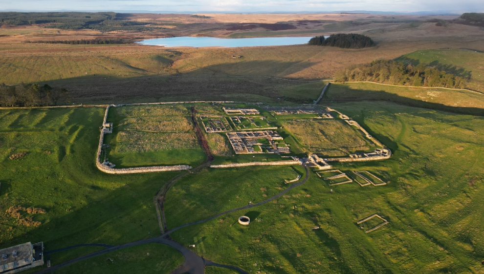
The Housesteads Roman Fort is also known as the Vercovicium. As one of the most iconic and well-preserved Roman forts in the country, the landmark historical site is a must see when walking this stretch of the Hadrian's Wall path. Built as a defensive wall by the Romans in northern England during the reign of Emperor Hadrian in the 2nd century AD, Housesteads would have housed around 800 soldiers and is remarkably well-preserved for a site of this size.
The Hadrian's Wall Path is a long-distance trail following the path of Hadrian's Wall. The hike is around 84 miles (135km) in length from Wallsend in the east to Bowness-on-Solway in the west. The section near Housesteads is a scenic stretch where hikers have the unique chance to experience the history of an authentic Roman fort alongside the natural beauty surrounding the wall.
This walk starts at the Housesteads car park, located on the Military Road just south of the fort. From here, take the gradually ascending path towards the fort, where you can explore the ancient structure and savour views of the nearby countryside.
The path carries on westward to Housesteads and Hotbank Crags, where you can tread on an authentic section of the historic wall. As you approach Crag Lough, the route takes a northward and then eastward turn, following another footpath that guides you past Ridley Common and Broomlee Lough. After circumnavigating King's Wicket, you'll encounter Milecastle 36, King's Hill, and Clew Hill before ultimately circling back to the fort and the car park.
2. Seahouses to Bamburgh Castle
- Distance: 3 miles
- Difficulty: easy
- Location: Northumberland Coast

Seahouses is a quaint seaside town in Northumberland. Overlooking the North Sea, the town is a historic fishing village that is still home to an abundance of maritime activity today. A brief trip to the harbour where an array of boats and vessels are moored gives you an idea of the proud fishing heritage that is still alive and well today.
The iconic Bamburgh Castle (one of Northumberland's most iconic landmarks) is located just a few miles south of Seahouses.
It dominates the skyline and is clearly visible from the village. This 3 mile walk commences from the harbour and follows the coastal path to the castle. Once you’re down on the seafront, head north. The direct path that runs parallel along the North Sea coast will take you all the way up to the grade 1 listed building.
During the Wars of the Roses in the 15th century, the castle was the site of several key battles and sieges. It was captured by Yorkist forces and played a role in the conflict between the Houses of Lancaster and York. The castle has been renovated numerous times and is featured in various films and television series, including the 1971 adaptation of Shakespeare's "Macbeth."
3. Whitby to Robin Hood’s Bay Walk
- Distance: 6 miles
- Difficulty: easy
- Location: North Yorkshire Moors National Park
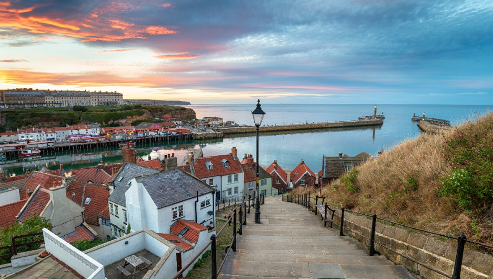
Whitby is a mysterious historic coastal town famous for it’s 199 step climb to the Abbey that overlooks the town and harbour. The eery atmosphere and misty mornings that Whitby is renowned for inspired Bram Stoker to pen his classic 1897 gothic novel Dracula.
Once you’ve finished exploring the harbour town, make your way up the famous 199 steps to the Abbey. Your walk begins from here, with a stunning coastline stretch featuing charming bays and cliff-top landscapes that make for a great photo opportunity.
Your well-marked route covers approximately 7 miles and is generally well-maintained and marked. Continuing along the path, you'll reach Saltwick Bay and the Whitby Lighthouse. The lighthouse is a remarkable structure that’s even more alluring in the winter, when fog adds to the intrigue of the building.
Passing through Oakham Beck and Rain Dale. Your trail eventually guides you to the picturesque fishing village of Robin Hood's Bay. The village is renowned for its quaint old fishermen's cottages. For a return journey, you can retrace your steps or transform it into a circular hike by following an inland track to Hawsker and Stainsacre. You can pick up this trail in the village just west of the coastal path.
4. Durham Riverside Walk
- Distance: 8 miles
- Difficulty: easy
- Location: Durham
This delightful walking route commences in Durham and showcases several the city’s prominent attractions. Steeped in rich history and natural beauty, the riverside path visits Durham Castle, Durham Cathedral, the Old Durham Gardens, and the more modern Durham Botanical Gardens.
To get going, make your way to the river side of Durham Castle. This Norman-era castle is perched atop a hill overlooking the river directly opposite the cathedral. Guided tours are available to the public and both the castle and the cathedral are integral parts of a UNESCO World Heritage Site. You can ascend the cathedral tower which stands at 217-foot (66-meter) to take in an unrivalled view of the city and surrounding countryside.
After exploring these historical gems, re-join the riverside path and head southward. You'll pass notable sites like the stone-arched Prebends Bridge, Durham Market Square, the Grade I listed Kingsgate Bridge, and the medieval Elvet Bridge.
The trail then veers eastward, leading you through Pelaw Wood before leaving the river's edge to visit the enchanting Old Durham Gardens. These charming gardens are multi-tiered and feature orchards, a walled garden, and a delightful gazebo.
Return to the riverside path and stroll to the Shincliffe Bridge. Here, you'll cross the river and follow the Houghall Discovery trail through the woods, which eventually leads you to the Durham University Botanic Garden. Here, you'll encounter exotic plants from around the world, including rare botanical marvels from the Far East. The garden also boasts glasshouses, an arboretum, an Alpine garden, and a serene bamboo grove.
Completing your visit to the botanical gardens, retrace your steps along the riverside path and head back toward the city centre to finish up.
5. Hartlepool Coastal Walk
- Distance: 10 miles
- Difficulty: easy
- Location: Hartlepool to Teesmouth National Nature Reserve
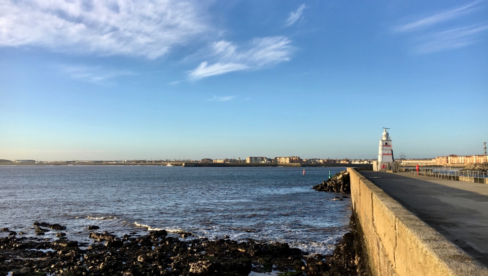
This accessible walk sees you follow the Tees Valley coastal path from Hartlepool, south through Seaton Carew into Seaton Dunes and Common Local Nature Reserve.
The hike starts in Hartlepool and culminates in the Seaton Dunes Nature Reserve, which is a protected wildlife area known for its rich biodiversity. Visitors can see various bird species, including waders and seabirds. The reserve is home to a variety of rare plant species which have adapted to their coastal environment.
This stretch of coastal path is exposed to the elements, making it great if you’re after a refreshing walk on a winter’s morning. Perfect for coast lovers, on a clear day, great views of the North Sea are on offer.
6. Roseberry Topping
- Distance: 2 miles
- Difficulty: medium
- Location: North Yorkshire Moors National Park
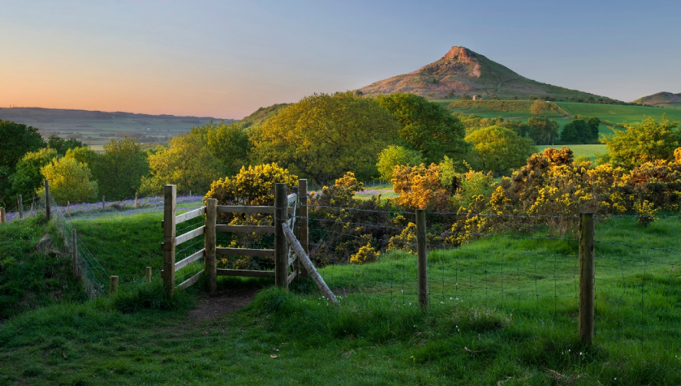
Roseberry Topping is a North Yorkshire hill climb located near the town of Great Ayton, which is about a 20-minute drive from Middlesbrough. Known for its distinctive shape and accessibility, Roseberry Topping is part of the North York Moors National Park, where scenic walks are plentiful.
Despite its modest height of just over one thousand feet (320m), Roseberry Topping stands out due to its unique, cone-shaped summit. It is often described as the "Matterhorn of Yorkshire" because of its resemblance to the famous Swiss mountain. The hill is composed of sandstone and has a steep ascent once you get near the summit.
Managed by the National Trust, there are many paths to the summit, all of which are immaculately maintained. This route to the top starts at the car park just to the west of the hill and heads along Roseberry Lane and through Newton Wood and Roseberry Common to the summit. Once you reach the top, you can make out wonderful views of the Cleveland plain and the Pennines in the distance.
From the summit, descend toward Newton Wood for another woodland section where you’ll see bluebells sprouting during spring months. Also look out for roe deer and woodpeckers on this part of the walk.
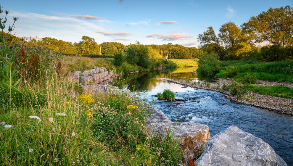
7. High Force Waterfall
- Distance: 7 miles
- Difficulty: medium
- Location: North Pennines Area of Natural Beauty
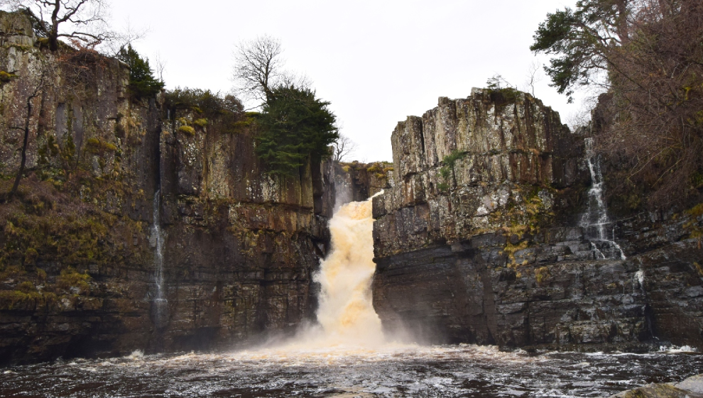
Described by many as the most impressive waterfall in the UK, High Force is a must see highlight of the North Pennines AONB.
The source of water for High Force is the River Tees. The river flows through a gorge before reaching the waterfall, and the sudden plunge at High Force is a striking contrast to the gentle meandering of the river further upstream.
High Force is aptly named, with a drop of over 20 metres. The water is driven onto the hard Whin Sill rock below, creating an audible and dramatic effect that’s unmatched by any falls in the country.
To reach the falls, make your way to the Bowlees Visitor Centre. From here, you’ll see the River Tees and the 18-foot (5.5-meter) Low Force Waterfall. Traverse the bridge spanning the river and join the Pennine Way, tracing your path westward through riverside woodlands until you arrive at the magnificent High Force Waterfall.
This breath taking site features ancient rock formations that date back over 300 million years. With excellent opportunities for photographing the falls from a number of angles, it’s easy to see why tourists visiting the Pennines flock to the falls.
The route ascends further into the hills south of the river, with elevations exceeding 1300 feet around Whiteholm Bank. Along the ascent, you'll be treated to panoramic views of the surrounding area and woodland below. The trail finishes up by moving back down to the river and car park.
8. Kielder Forest Lakeside Way
- Distance: 22 miles
- Difficulty: hard
- Location: Kielder Forest, Northumberland
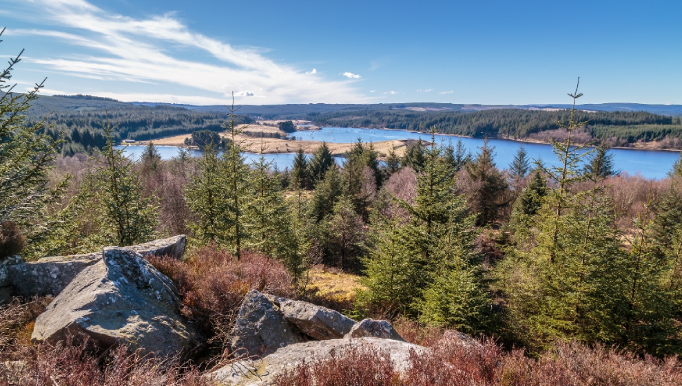
Kielder Forest is an enchanting woodland space in Northumberland. Kielder is the largest man-made forest area in the UK and is home to red squirrels, deer, and a variety of avian wildlife (including ospreys) that you’re likely to encounter when out hiking.
Because of the size of Kielder Forest (650km square), this extensive lakeside walk is easily broken down into more accessible trail segments. Most of the route follows the reservoir (the largest man-made lake in the UK at 2.5 square miles) and can be walked, hiked, or cycled.
The trail sees you pass Kielder Dam and Kielder Castle, home to a superb visitor centre where you can enjoy exhibitions and a coffee at their superb café. The castle serves as the hub for cycling activities within the park. You can rent a bike or have your own repaired if necessary. You'll find it situated at the northern edge of Kielder village, overlooking the reservoir.
Honourable mentions
The northeast of England is one of the best parts of the country for hiking and outdoor enthusiasts. Unfortunately, a lot of our favourites couldn’t make the list. If you’re after more inspiration, be sure to walk some of the honourable mentions listed below:
- The Cheviot Hills, Northumberland
- Crimdon Dene Beach, Hartlepool
- Simonside Hills, Northumberland
- Cragside National Trust Site, Rothbury
- Hamsterley Forest, Durham
- The Tees Barrage Trail, Middlesbrough
- Northumberland National Park, Northumberland
- Derwent Reservoir, North Pennines Area of Natural Beauty
- Scaling Damn Circular, North Yorkshire Moors National Park
Last updated Wednesday 20 September 2023
First published on Wednesday 20 September 2023